Wisconsin Supreme Court settles long-standing boundary dispute along Henn Road
For nearly 100 years, landowners recognized a particular road as the boundary line between the properties. A 2005 survey uncovered a monument that suggested otherwise. But the Wisconsin Supreme Court held that common usage and acquiescence was the best evidence available to determine the boundary line in the dispute.
By Joe Forward, Legal Writer, State Bar of Wisconsin
Feb. 4, 2010 – Where a boundary line cannot be determined from deed descriptions, and original survey monuments have been lost or destroyed, the court must use the best evidence available to determine the legal boundary line, the Wisconsin Supreme Court recently held.
In Boerst v. Opperman, 2011 WI 5 (Feb. 3, 2011), a unanimous supreme court – in an opinion written by Chief Justice Shirley Abrahamson – agreed that the best evidence available was evidence that a road, Henn Road, served as the long-honored boundary line at issue.
Henn Road, a public highway in Ashland County, runs north and south then curves and runs west. Landowners bordering Henn Road on the east, west, and north had long believed that Henn Road served as the boundary line between the four parcels affected.
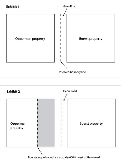
The Boersts own a section of land to the east of Henn Road. The Oppermans own the section of land to the west of the road (see exhibit 1). Landowners to the north were similarly impacted by the dispute between the Oppermans and Boersts, and all affected parties joined the suit.
The road was originally surveyed in 1886 to establish a public highway. In 1912, another survey altered the Henn Road boundary line, and litigation ensued in 1917 based on the 1912 survey.
But the parties in that dispute stipulated that Henn Road served as the boundary line between the east-west parcels now owned by the Boersts and Oppermans.
In 2005, however, a county surveyor uncovered a concrete monument northwest of the Henn Road intersection (the point at which Henn Road curves and runs west).
The surveyor believed the monument was placed following the 1912 survey and marked the true corner common to the four parcels. Thus, he recorded a U.S. Public Land Survey Monument Record tie sheet establishing the monument as the true intersection.
This moved the recognized boundary line between the Boersts and Oppermans west of Henn Road by 600 feet. The Boersts filed suit for a declaration that they owned the additional land to the west of Henn Road (see exhibit 2).
Best evidence
The Ashland County Circuit Court determined that longstanding common usage and acquiescence was the best evidence available to determine the boundary line, and all parties honored Henn Road as the boundary line for many years. The appeals court affirmed.
On appeal to the Wisconsin Supreme Court, the Boersts argued that extrinsic evidence – common usage and acquiescence – should not have been used to determine the boundary line.
But the supreme court explained that the “concept of acquiescence in the evidentiary sense is often used in cases resolving conflicts between a landmark and a survey” and categorized the case as one “in which a survey is in conflict with a longstanding landmark,” such as a fence.
Examining the “survey/fence” cases, the court explained that a circuit court first determines whether a boundary line can be determined by a deed or original monument. If not, the circuit court must look to the best evidence of the boundary line.
Thus, the supreme court applied the rule that “an ancient fence (or other landmark) may be competent evidence of the location of the boundary when original monuments cannot be found,” and noted five important facts concerning the dispute.
The original (1886) monument no longer exists, the court noted, and there was no competent evidence to determine where the original section corner monument was originally placed.
The court also noted that there was no clear and convincing evidence that the resetting of the corners in the 1912 survey (upon which the 2005 tie sheet was based) was correct, and pointed to City of Racine v. Emerson, 85 Wis. 80, 55 N.W. 177 (1893) to conclude that “resurveys may be unreliable as evidence of a boundary line.”
Further, no party could show where the boundary line existed by other clear and convincing evidence and the original boundary line could not be determined solely by deed descriptions.
Thus, the court concluded that “in determining the boundary line by evaluating the evidence of common usage and acquiescence and not by using the legal doctrine of acquiescence, the circuit court applied the correct legal analysis in the present case,” and affirmed.
Attorneys
Joe Thrasher of Thrasher, Doyle, Pelish & Franti, Rice Lake, represented the Oppermans. Vicki Zick of Zick & Weber Law Offices LLP, Johnson Creek, represented the Boersts.
Related articles
Appeals court clarifies doctrine of acquiescence in boundary dispute – May 11, 2010
