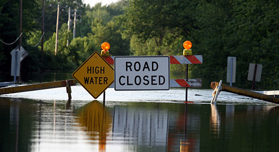
Over the past decade, Wisconsin residents from Coon Valley to Darlington, Green Bay to Madison, and Mazomanie to the Town of White River, have evacuated their homes, been left stranded on flooded streets, and even lost their lives during record rainfall. In 2017, floods in southwest and west central Wisconsin were declared a federal disaster.
Western Wisconsin was hit by deadly 2018 storm events. And, tragic floods – technically classified as “500-year floods” – struck our northern counties in 2012, 2016, and 2018.1
Floods cause death and significant property damage and can exacerbate pollution and waterborne illness.
The challenges presented by changing rainfall patterns in Wisconsin are also opportunities to build greater flood resilience. Scientists from the Wisconsin Initiative on Climate Change Impacts have found that most of Wisconsin is experiencing more intense rainfall events, hotter summers and warmer winters, and a shift from snowfall to more rainfall. These changes will likely lead to more flooding.
In his recent Environmental Law Section Blog article, Caleb Tomaszewski highlighted the litigation risks of persistent high water levels. This article explores related challenges from intense flooding and efforts to reduce and mitigate those risks.
Flood Resilience
Resilience, in ecology, is the capacity of an ecosystem to resist damage and to recover. Flood resilience arguably includes purchasing flood insurance, which can allow a community to return and rebuild, albeit to the same flood risk, post flood.
Flood resilience also involves changes to the landscape to reduce flood damage – by increasing the land’s capacity to absorb water, raising or moving buildings and infrastructure out of the floodplain, and allowing people to safely evacuate.
Finally, flood resilience can mean designing buildings and cities to safely allow floods to come and recede with little damage.
Here are some examples of regulatory and planning efforts in Wisconsin that have encouraged such resilience.
Updated Ordinances
In some municipalities, updated ordinances are guiding future development toward flood resilience.
Stormwater: In some cities, stormwater ordinances now require that developers more comprehensively manage the runoff created by new impervious surfaces.
For example, the Milwaukee Metropolitan Sewerage District (MMSD) updated its regulations in 2019 to require that property owners add green infrastructure – e.g., porous pavement, vegetation – if the development project will add more than 5,000 square feet of impervious surface.2
Madison revised its stormwater ordinance in 2020 to require new development to handle heavier rainfall events by passing overflows without impacting private structures.3 These changes can incrementally reduce the impact of rain events over time.
Floodplain: In Wisconsin, communities must adopt ordinances that regulate floodplains. Wisconsin has developed state standards for local floodplain zoning ordinances that, in several respects, exceed the federal requirements.
Some counties and municipalities have added further provisions to reduce floodplain impacts. For example, in Waukesha County, any authorized fill in the floodplain must be compensated one-to-one by replacement of floodplain storage capacity.
Building codes and contracting: Wisconsin has uniform building codes that largely do not allow for different local standards, but builders can still design and build flood-resistant buildings. In a recent article, Kimberly Hurtado explained the challenges that more frequent natural disasters present for the construction industry and the opportunities for using new methods and materials to make buildings flood tolerant.4
Hurtado recommends that builders signal what risk their buildings are designed to address and what they do not, by explicitly including those promises in their contracts. She suggests that designers and contractors may wish to add “resiliency benchmarks” to contracts, for example “adding building components and landscaping that divert specific quantities of water from a structure by passive and active means in the 500-year floodplain.”
Hazard Mitigation Planning
Meaningfully addressing flooding also involves undertaking public works projects, moving buildings out of the floodplain, raising or rebuilding structures, and restoring the natural floodplain.
Communities understand their flood risk and mitigation opportunities via planning processes, and hazard mitigation planning and grants allow communities to redesign themselves for lower flood risk.
Flooding is a component of the hazard mitigation planning required to receive certain types of disaster assistance. These plans have helped municipalities, counties, and Tribal Nations within the borders of Wisconsin identify their flood risk.
The Mississippi River Regional Planning Commission was recently awarded funds to develop a plan to move businesses and other key infrastructure out of the floodplain in the Kickapoo River Watershed.
Similarly, the City of Darlington, which experienced floods in 1950, 1959, 1969, 1990, and 1993, developed a flood hazard mitigation plan that provided a blueprint for a suite of mitigation actions to fundamentally redesign its downtown. It elevated and retrofitted buildings, raised utilities, created a new business park outside the floodplain, and acquired and demolished buildings. Those efforts have helped it prepare for and recover from recent, frequent floods.
Natural flood management encourages flood resilience by emulating and restoring the natural functions of wetlands and floodplains. For example, in partnership with the Wisconsin Wetlands Association and others, this fall, Ashland County began a project to evaluate options for floodplain reconnection and strategic stream and wetland restoration to protect public infrastructure.
Over time, MMSD’s Greenseams and Working Soils programs have protected thousands of acres of undeveloped and working lands through purchase and agricultural easements, respectively, to encourage natural water retention and mitigate flooding.
The state has played an important role in funding flood resilience. After the 1993 floods, the Legislature created the Municipal Flood Control (MFC) grant program that allows communities to buy land, floodproof buildings and infrastructure, restore riparian watercourses, or remove structures. These grants have been used along with Federal Emergency Management Agency (FEMA) money and HUD Community Development Block Grants to implement flood mitigation projects. MFC grants have allowed communities to reduce the risk of costly flood damage, and the program could be expanded as demand exceeds available funds.5
Promoting Soil Health to Reduce Flood Risk
Flooding is not only an urban issue. Recent studies have shown that land management practices that provide other benefits may also reduce the risk of rural flooding.
A recent meta-analysis by researchers Andrea Basche and Marcia DeLonge found that practices that promote soil health also increase water infiltration, thereby decreasing runoff. This understanding underpins some of MMSD’s work and that of the Natural Resource Conservation Service in Wisconsin, where practices such as no-till farming, cover cropping, and rotational grazing have helped farms in Greenleaf, Wisconsin, and elsewhere to reduce erosion and improve water infiltration.6
Neighboring states have begun passing soil health bills to further encourage this work, and the Wisconsin Legislature could similarly support farmers developing healthier soils and reduce flood risk.
Updating Rainfall Data and Floodplain Mapping
The current federal floodplain maps and many references to rainfall events in Wisconsin’s codes are based on historic data going back decades. In addition, many floodplains have not been mapped at all, or are based on outdated data.7 These gaps allow serious flood loss to take communities by surprise.
If weather patterns shift as modeling predicts, the maps and references will become increasingly outdated. The Governor’s Task Force on Climate Change called for updating these references to reflect rainfall projection models. Federal legislation may also provide a dedicated funding stream for updating rain-event data, including that used in Wisconsin.
Equitable Flood Resilience Policy Must Be a Priority
Wisconsin’s Department of Health Service has launched the Wisconsin Risk Assessment Flood Tool to allow communities to evaluate flood risk, along with using the Centers for Disease Control and Prevention (CDC) Social Vulnerability Index and location of emergency management resources, among other mapping layers.
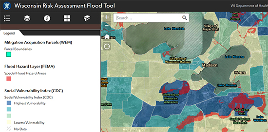
In this image, the Wisconsin Department of Health Services Risk Assessment Flood Tool shows flood hazard zones and social vulnerability areas in Madison and surroundings.
As with many natural disasters, flooding has an important environmental justice component and damage from floods is inequitably distributed. As Christa Westerberg explained in her July 2020 Environmental Law Section Blog article, without “more formal action, we can expect environmental disparities to persist.”
Likewise, without efforts to ensure that everyone benefits from proactive flood planning, we can expect similar disparities in the floods to come. Localities must plan for the needs of community members who are more at risk because of income inequality, decreased mobility, their dependency on the grid to power life-saving devices, or other reasons. Communities should meaningfully involve those community members in the planning process and seek to redress inequities.
Conclusion: Steps Forward and Back
Wisconsin has taken steps to encourage flood risk planning and decrease flood damage. The Governor’s Task Force on Climate Change released its report in late 2020, and recommends several actions related to flood resilience, including calling for a coordinated, statewide flood resilience plan. Lawmakers introduced the Flood Prevention and Resilience Plan this spring.
Yet, the Legislature has also decreased the ability of local governments to require stormwater ordinances that reduce runoff, and allowed aspects of local floodplain ordinances to relax to the federal minimums. The federal government has limited federal protections for many wetlands which provide important storage for floodwaters.
Nevertheless, Wisconsin communities have deep experience surviving, recovering, and rebuilding from floods. The next decades are likely to bring more challenges and further opportunities to work as a state to address those challenges through smart, inclusive planning and governing.
This article was originally published on the State Bar of Wisconsin’s Environmental Law Section Blog. Visit the State Bar sections or the Environmental Law Section web pages to learn more about the benefits of section membership.
Endnotes
1 Northwest Regional Planning Commission, Northwest Wisconsin Flood Impact Study, HAZUS-MH Level 2 Analysis, pp. 1-3, 294, Nov. 2018.
2 Surface Water and Stormwater, Chapter 13, Milwaukee Metropolitan Sewerage District (2019); Milwaukee Metropolitan Sewerage District, “Frequently Asked Questions.”
3 See Madison, Wis., Gen. Ordinances, ch. 37.
4 Kimberly Hurtado, “In a world rocked by climate change, firms must adjust,” Idaho Business Review, Feb. 18, 2020.
5 See “Wisconsin Grant Program Helps People Relocate From Flood-Prone Areas,”Pew Charitable Trusts Issue Brief, Nov. 19, 2019.
6 See Soil Health, USDA Natural Resources Conservation Service, Wisconsin.
7 Association of State Floodplain Managers, Testimony: An Examination of Federal Flood Maps in a Changing Climate, before the House Committee on Science, Space and Technology Subcommittee on the Environment & Subcommittee on Investigations and Oversight, pp. 13-18, Feb. 27, 2020.
